By Jia Feimao |
Four Chinese vessels patrolled undersea cable corridors and reportedly created Beijing's first-ever seabed map of the area during a five-day operation east of Taiwan that ended June 10. The exercise marked an escalating response to recent Japanese-Philippine maritime boundary talks.
Japanese Prime Minister Sanae Takaichi and Philippine President Ferdinand Marcos Jr. conferred on security in Tokyo on May 28. They upgraded their countries' ties to a comprehensive strategic partnership and formally launching negotiations to delimit their Exclusive Economic Zones (EEZs) and continental shelf boundaries.
The proposed boundary area lies in waters east of Taiwan, where the EEZs claimed by Japan, the Philippines and Taiwan partially overlap.
China's Foreign Ministry said Japan and the Philippines had committed "a severe violation" of the United Nations Convention on the Law of the Sea and other international laws. Any boundary negotiations involving waters east of Taiwan "must involve China," said spokeswoman Mao Ning.
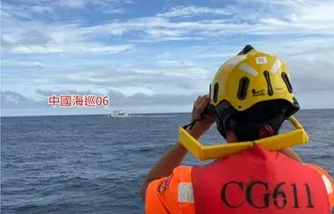
![Taiwan's CGA deployed the patrol vessel Changbin to shadow China Coast Guard vessels operating off Taiwan's southeast coast on June 1. [Taiwanese CGA]](/gc9/images/2026/06/15/56595-1-370_237.webp)
![A map shows Chinese maritime enforcement vessels east of Taiwan on June 9 during Beijing's ministry-level operation. [X/Taiwanese National Security Council Secretary-General Joseph Wu]](/gc9/images/2026/06/15/56596-map-370_237.webp)
"There is no doubt that Beijing is putting greater pressure on Taiwan and on countries that are strengthening ties with Taiwan," Bonnie Glaser, managing director of the Indo-Pacific program at the German Marshall Fund, told Taiwan's Central News Agency (CNA) by email.
Seabed mapping
Over 10 days, Beijing dispatched three waves of maritime enforcement operations east of Taiwan, escalating from coast guard patrols to a ministry-level campaign.
Two China Coast Guard vessels opened the effort on June 1 with what Beijing called "law enforcement patrols" east of Taiwan. Two days later, another pair sailed off eastern Taiwan before entering Japan's EEZ south of Yonaguni Island and, for the first time, claiming the area fell under Chinese administration, Japanese media reported.
The campaign culminated in a five-day Chinese Transport Ministry operation, with vessels from Fujian and Guangdong provinces traveling roughly 1,030 nautical miles, inspecting 198 vessels and taking "corrective" action against three ships, state-owned China Central Television (CCTV) reported.
Four Chinese government vessels entered Taiwan's restricted waters south of the island; Taiwan's Coast Guard Administration (CGA) scrambled vessels in response, it said.
The Chinese vessels patrolled undersea cable corridors including Japanese and Taiwanese cable routes. The operation produced Beijing's first Chinese-made seabed map of waters east of Taiwan, according to Yuyuan Tantian, a Weibo account affiliated with CCTV.
"They've demonstrated through their actions that, in the event of an emergency, they would cut undersea cables to sever the infrastructure of Taiwan and its neighbors," Chisako Masuo, a professor of international relations at Kyushu University in Fukuoka, Japan, told Nikkei Asia.
The seabed surveys likely were meant for military use, she added: "There are many beaches along the eastern coast of Taiwan that are suitable for amphibious landings."
'Near seas'
Waters east of Taiwan have become China's "near seas," waters where Beijing is "present, exercises jurisdiction and governs," Yuyuan Tantian declared.
These moves extend Beijing's "belittlement lawfare," a strategy it has used since June 2022 to build ostensible evidence of jurisdiction around Taiwan and is now applying to Taiwan's eastern EEZ, Chieh Chung of Taiwan's Institute for National Defense and Security Research wrote in Storm Media.
The patrols east of Taiwan and their outsized official publicity "cannot be taken lightly," Chieh wrote. Beijing may use the Japan-Philippines talks as a pretext to pressure Tokyo and Manila into negotiating vessel conduct rules directly with China. If they comply, they would bypass Taiwan and hand China a victory in its drive to undermine Taiwan's international legal standing.
Cognitive warfare
Alongside that legal pressure, Beijing targeted Taiwan's domestic debate with propaganda.
Shortly after Japan and the Philippines announced the EEZ talks, an image showing only the Japanese and Philippine EEZ boundaries began circulating on social media.
Someone, likely with pro-Beijing intentions, had stripped Taiwan's EEZ layer from it. Doing so recast negotiations as an exercise with no role for Taiwan.
The original image, before the malicious alteration, came from the U.S. think-tank Center for Strategic and International Studies, the fact-checking organization MyGoPen found.
Taiwan pushes back
Taipei is rejecting any attempts to cut it out of negotiations.
The talks and any resulting accord will not affect Taiwan's sovereign rights under international law or existing fishery agreements, Taiwan's Foreign Ministry said. The Japan-Taiwan Exchange Association said any accord would not be binding on third parties, according to Taiwan's CNA.
"China certainly wants to use this opportunity to drive a wedge among Taiwan, Japan and the Philippines, but judging from the three governments' official statements, it has not worked," Yeh Yao-yuan, professor of international studies at the University of St. Thomas in Houston, Texas, told Focus.
Beijing has no right to interfere in waters east of Taiwan, and domestic opinion should not fall into its narrative of "law enforcement in name, expansion in fact," Foreign Minister Lin Chia-lung told the Taiwanese legislature on June 10.
The Republic of China (Taiwan) holds sovereign rights throughout its EEZ east of Taiwan, Taiwan's CGA said.